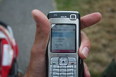
 Last month I got a Nokia N70 with Co-Pilot software and a bluetooth GPS reciever. Of course, I needed to test it’s accuracy so I dragged the family off to Greenwich Observatory, home of the Greenwich Mean Line. That’s 0 degrees longitude for those who have yet to dabble in the strange world of geo-tagging.
From the start I was disappointed that the phone couldn’t automatically geo-tag photos. I have tried to use ZoneTag from Yahoo Research but can’t get it working. Tom Coates doesn’t seem to have any problems so maybe it’s just me. To add insult to injury, my digital SLR doesn’t have GPS built in (do any?), nor does it have bluetooth or wifi so it can’t talk with my external GPS reciever. So what to do if I want to geotag stuff? Well, until now I could go to google maps and find the location, then grab the latitude and longitude and add it to the tags of my photos on flickr.
 Now, thanks to flickr’s new geotagging feature, I can just go to the photo organizr and add geo data to my photos. It’s not quite the same as them automatically getting tagged but it’s better than the old way. Then when someone visits my photo stream, they can click the map tab under a photo that has been geotagged and view it on a map, a satellite image, or a hybrid. To the left is an example of the photo above which I tagged with the locational data.
Part of the fun of flickr is meeting other flickr users who have taken photos of similar subjects, or in the same places, as you have. Using the new geotagging features, it’s possible to see "everyone’s photos" from a specific area. I had a look to see what other photos have been posted from the area around Greenwich:

Pretty cool results and, I think, quite useful if used by communities or groups to photo-plot landscapes, create tourist maps, etc. Flickr users seem to think it’s a great idea too – flickr expected a million photos to be tagged in a month, maybe within a few weeks, but over 1.2 million were tagged on the first day alone. Try it now before the servers grind to a halt…
The problem is that Yahoo Maps of England are very low quality. For those who are interested in areas not well covered by Yahoo Maps, Panoramio.com can be an alternative.
In Panoramio you can also locate your photos via drag and drop interface using Google Maps. You also can watch the photos in Google Earth through KML feed.
Eduardo